

VITO Remote Sensing is a Belgium-based supplier of satellite imagery, Earth observation information, geospatial analysis, and remote-sensing services for agriculture, environmental monitoring, climate studies, water management, infrastructure, and security. The organization transforms satellite, aerial, and drone data into useful information for farmers, food industry companies, research institutions, government bodies, and various other entities. Its agricultural uses assist with crop monitoring, yield evaluation, precision farming, and assessing farming methods.
VITO Remote Sensing utilizes Earth observation technologies, image processing, artificial intelligence, and data analysis systems to analyze alterations in vegetation, land usage, and environmental state. Its services merge satellite imagery with weather, field, and various spatial data to deliver insights at both the field and regional levels. The organization also participates in global land-cover and cropland mapping projects, such as WorldCereal and Copernicus Global Land Services.
Key services include:
- Agricultural monitoring: Crop growth and health monitoring, yield estimation, field-level analysis and precision agriculture.
- Potato industry solutions: Crop monitoring and yield prediction through platforms such as WatchITgrow, supporting potato growers and other agricultural stakeholders.
- Earth observation data: Satellite imagery, geospatial datasets and processed information for local and global applications.
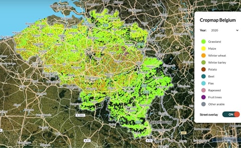
- Crop mapping: Cropland and crop-type mapping to support agricultural monitoring and food security assessments.
- Remote-sensing analysis: Image processing and integration of satellite, drone, meteorological and field data.
- Environmental monitoring: Land-cover change, biodiversity, vegetation condition, forest management and natural-resource assessment.
- Climate and water applications: Monitoring of climate-related conditions, water resources and environmental change.
VITO Remote Sensing offers technologies that assist farmers and industry players in evaluating crop growth, predicting yields, detecting field variations, and assessing resource utilization. The WatchITgrow platform began as a monitoring and yield-prediction tool for the potato sector and later expanded to cater to a wider range of agricultural applications. These services based on data can guide choices regarding crop management, irrigation, fertilizer application, and sustainable farming methods.